 At the recent MVP summit, I attended a Mash-up lounge event. It was a bit Web 2.0-ey, but basically they had a bunch of bean bags, fake palm trees, and members of the Windows Live team and some Virtual Earth MVP's around to help folks get up to speed with the Windows Live API's. (Thanks to Tyler and Robert, Virtual Earth MVP's from InFusion Development for helping me with some sample code to grok). This is a whole area that I've not really been paying attention to in the past year, so I dropped by to see what the deal was and have a play.
I have to say, I'm impressed. It is super easy to control the Virtual Earth map control from your JavaScript, and the documentation is pretty decent. Now, as I freely admit, I am no expert on the differences between the various mapping providers around and their web interfaces - but I will say this; The local.live.com data for Ireland and Northern Ireland is by far the best of the mapping sites that I've seen. I also love the driving instructions and the custom print capabilities. I get the feeling that if local.live.com was not made by Microsoft then there would probably be more fuss about it - but hey ho. I've just come back from a trip to Redmond so I must have had my borg implant secretly added if I'm feeling Microsoft are being unjustly treated :-)
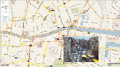
Anyway, on my return, I was having a chat with my good friend Rob Burke about some of the exciting possibilities that the mapping API gives you. As an example, I did this very quick mash-up of traffic cameras from the Dublin City Council website and a Virtual Earth Map. It is very crude as it only took me 5 minutes to write the HTML (in Notepad2) and then a further 15 figuring out the lat/long positions of the cameras - but hopefully you'll get the point. If anyone wants the GeoRSS data I used to create the map then here it is.
Dublin City Center Traffic Cameras - data from Dublin City Council.

Martin, it was great to meet you at the MVP summit. Thanks for the beer! I'm a terrible blogger (it's been over a year since my last post) but I love your mashup.
I've checked, and the aerial topography (big word!) for places like the lake district (and even Spain!) is far superior in virtual earth than either yah** or g**gle.